Northern California’s rugged coast range creates significant challenges for getting into and out of Humboldt Bay. The region’s beleaguered and inadequate transportation infrastructure has long been cited as the greatest obstacle to economic development here, but some locals quip that they like it this way. The native Wiyot people devised Humboldt Bay’s first transportation network, maintaining numerous trails and canoe routes around the bay and to its adjacent watersheds. Foot and mule trails formed the initial overland routes for the bay’s first non-native residents as well, who traveled eastward to gold mines in Trinity County and southward along the Sonoma Trail—a passage that by 1877 was transformed into a stage road where the journey to San Francisco could be made in three to four days. Nineteenth century Humboldt Bay residents and commerce more typically traveled southward by schooners and steam ships, though this journey was fraught with legendary peril. The completion of the Northwest Pacific Railroad in 1914, which finally linked Eureka all the way to the Sausalito ferry, largely supplanted the ships and dirt roads as a safer and speedier method for transport—at least until the arrival of the state highway system.
Humboldt Bay’s very first railroad (actually a horse-powered one) was built in 1855 on a wharf that extended a mile from the town of Arcata (then Union) to a ship channel in the center of Arcata Bay. Within 20 years, rail spurs with steam locomotives were built into the bay’s major tributaries for transporting increasingly inaccessible timber downstream. By the late nineteenth and early twentieth centuries, various lumber mills had constructed a network of rail lines that encircled much of the bay, and by 1906, this network had largely consolidated under the aegis of the Northwestern Pacific Railroad, which soon linked the system all the way to Marin. By 1996, the increasingly ramshackle northernmost line was put out of commission, thus severing Humboldt County’s rail link with the rest of the world. The tracks along the bay’s shoreline are dilapidated in places but still largely intact, and are now publically managed by the North Coast Rail Authority.
This disused bay railway has long been a focus of community interest, and is being gradually transformed into a regional trail. This trail will eventually follow the shoreline from the Elk River Wildlife Area just south of Eureka to the Arcata Skate Park—a journey one way of about thirteen miles. The southernmost sections are particularly appealing in that cyclists and hikers can enjoy many historically and culturally significant sites, including the former locale of an ancient Wiyot village, a magnificent view of the bay’s petroleum depot, as well as the crumbling remains of the old Holmes-Eureka mill site—an artistically-embellished memento of the local timber industry’s once mighty and still complicated legacy.
As soon as state Highway 101 made its way to the bay, opportunities for adventuresome travel arrived along with it. By 1923, most of Northern California’s gloriously scenic Redwood Highway had been paved, which shortened the drive from Sausalito to Humboldt from more than two days to a mere fourteen hours. The current section of 101 between Eureka and Arcata was paved and ceremoniously opened to traffic in 1925, but the Jazz-age operators of the vintage Dipper Dredges that fashioned its grade from marsh mud and gravel could never have predicted the threat it now faces. This roadbed has long been protected from the bay’s direct contact by the railroad and an assemblage of old dikes and tide gates, but these buffers are no match for this century’s sea level rise. An extra high tide—with the bay creeping uncomfortably close to the median strips—can make driving this highway seem eerily similar to traversing a causeway. And a causeway it will need to become, because this critical thoroughfare will face inundation by high tides by 2050, and inundation by everyday tides before 2100. To stave off submersion, Humboldt Bay’s 101 corridor will need to be raised a minimum of three feet, and its accompanying infrastructure—including water and gas mains—will need to be moved.
In addition to dry land, Humboldt’s cars require fuel, and this petroleum gets there mostly by sea. Two and a half million gallons of gasoline is barged in approximately three times a month within one of two 87,000-barrel capacity ships, the Sause Bros Company’s Morro Bay and Monterey Bay. These ships sail from the sprawling Chevron Refinery in Richmond, CA, to the Eureka Chevron Terminal at the foot of Truesdale Street, where the fuel is disgorged and then stored at a tank farm for distribution all over the county in shipments of about 40 truckloads a day. Sixty-five percent of the bay region’s petroleum is currently barged in this way, with the remainder delivered in trucks northward on Highway 101. Petroleum currently comprises 34% of the county’s total energy consumption (with natural gas and biomass comprising much of the rest) so transportation takes a pretty big bite from this energy pie.
Maritime transport was paramount before the railroads and highways arrived. As early as 1853, one hundred seventy three ships filled with lumber had reached San Francisco, and by 1855, Humboldt mills had found markets in places as distant as Hawaii and Hong Kong—introducing the bay to international trade. Countless ships once crossed the bay’s entrance every year (transporting people, lumber, seafood, agricultural products, and myriad other commodities) but this traffic has greatly diminished over the years. The only big ships now include a semi-weekly fuel barge and about a dozen or so gigantic bulk carriers per year, arriving to load their hulls with whole logs or wood chips for international export. Hundreds of smaller vessels come and go every day, however—including trawlers and crabbers and innumerable pleasure craft, so long as seafaring conditions are right.
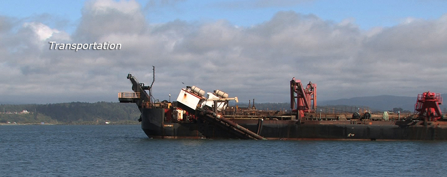
The bay’s harbor entrance—despite well over a century’s worth of fortifications—remains one of the west coast’s most hazardous crossings, and its channel must be frequently dredged. The Federal Army Corp of Engineers annually enlists a gigantic suction dredge barge that vacuums up countless boatloads of sand, making countless trips to the ocean to dump it. The ship channel must be kept at least minus 48 feet or Humboldt Bay will lose its designation as a deep-water port, and the community will lose millions of dollars in annual revenue. This Federal largess is essential, but unfortunately hasn’t always been completely dependable. Disposal of dredge spoils is another ongoing challenge, but plans are afloat to possibly use this material to restore the elevation of subsided marshlands or fortify old levees in advance of forthcoming sea level rise. To keep this community moving along—whether by land or by sea—requires that the earth must continuously move with it.
